Faculty of Engineering
Department of Electrical and Electronic Engineering
- Key words
- Satellite remote sensing, water quality measurement, monitoring of marine debris and microplastics, verification of natural disaster damage

Doctor of Science / Professor
Takashi Aoyama
Education
Department of Physics, Faculty of Science, Nagoya University,
Tohoku University Graduate School of Science, Geophysics Master’s and Doctoral Program
Professional Background
Associate Professor, Tohoku Polytechnic College, Part-time Lecturer, Tohoku University,
Associate Professor/Professor, Fukui University of Technology, Faculty of Engineering, Department of Space Communication Engineering, Electrical and Electronic Engineering
Consultations, Lectures, and Collaborative Research Themes
Lectures and technical consultations from basic to applied on satellite remote sensing technology.
Monitoring of marine debris (including microplastics), Estimation of water quality of eutrophic lakes, etc.
Main research themes and their characteristics
「Extraction of marine debris in the Sea of Japan using satellite images」
Coastal pollution consisting of washed-up debris along beaches is seriously impacting the ecosystems of the Sea of Japan, and collecting this debris is difficult. In an attempt to develop mitigation measures to address this problem, it is important to understand the debris flow in the Sea of Japan. If the position and quantity of marine debris drifting in the ocean can be determined before it reaches the seashore, then it may be possible to implement mitigation measures before the debris is deposited on beaches. Furthermore, we can expect that illegally dumped debris will also decrease as the source could be identified by considering ocean currents.

As a first step to resolving this problem, we examined methods for extracting pixels containing debris drifting in the sea using high-resolution satellite images. The presence of small items of marine debris cannot be directly confirmed, even in high-resolution satellite images. In order to extract candidate pixels containing marine debris, pixels with spectral characteristics that differ markedly from the characteristics of the surrounding seawater and wave crest need to be identified.
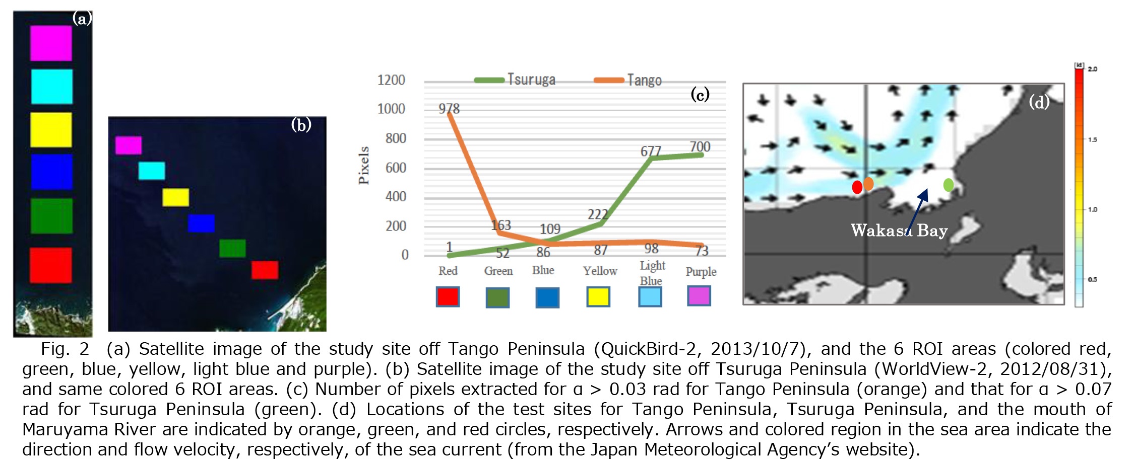
We therefore developed the method for identifying marine debris floating on the Sea of Japan using SAM (Spectral Angle Mapper; see Figure 1). Then, the validity of the SAM-based method for identifying buoys was discussed (detail of this work was discussed in paper (3) below). The results indicate that the extraction method using SAM is an effective method to extract marine debris smaller than the spatial resolution of a satellite image.
Moreover, it has been confirmed that the locations of the sea currents and rivers affect the distribution of marine debris in the Sea of Japan (see Figure 2 and paper (3) for detailed discussions).
Major academic publications
(1) Takashi Aoyama, “Algorithm for estimating the chlorophyll-a concentrations in water areas with different qualities from satellite data”, SPIE - The international Society for Optical Engineering, Vol. 7858 (2010), 785819-1 - 785819-8
(2) Takashi Aoyama, Motohiko Nagano, “Test of MODIS-type Cloud Mask Algorithm in Comparison with Collocated Observations by infraredthermograph on Ground”, Journal of The Remote Sensing Society of Japan, Vol. 31-3 (2011), 323 - 333
(3) Takashi Aoyama, “Extraction of marine debris in the Sea of Japan using satellite images”, SPIE Asia-Pacific Remote Sensing, Vol. 10778 (2018), 10778R-1 - 10778R-8